
|
Antares charts |
|
Very Large scale wgs 84 electronic charts |


|
Latest news
New charts for 2023: there are 41 new charts and 32 updated charts for the 2023 season. Those who have subscribed to either of the last two sets (2022 and 2020) will receive email notification.
Shoal-draught boats, typically trailer-sailers. We are putting more emphasis on really sheltered and exciting locations that could be used by shoal-draught boats, especially those that can dry out. See OUR CHARTS Recent Developments Please email ideas for such locations.
Full lists of our charts can be found via the ‘Our Charts’ tab above or by tapping here
Corrections relating to previous editions of our charts can be found on the corrections tab .
Setting up our charts in the new Memory-Map for All navigating app is very simple on reasonably recent tablets, phones and computers. It is available for all platforms and makes things extremely straightforward
Most of those who choose not to use Memory-Map navigating software tend to be confident with technology but those who are not can seek help from Steve Davis, who trades as London Chart Plotters. We have no formal relationship with Steve but he has helped a number of users in the past and his services are very inexpensive. |
|
If you are not familiar with our charts please look around this website before buying, especially ‘OUR CHARTS’; ‘MAKING’ and ‘USING’
BUY our 2023 charts(£20 for up to 5 of your devices) or update your old charts** (£9)
**Those who bought our 2022 charts on or after 1st October should receive an email offering a free update
(**If you have our 2020 or 2022 charts you can acquire a 2023 set at a reduced price—just follow the link above)
There is a direct download and automatic setup facility for the Memory-Map version, which is recommended. |
|
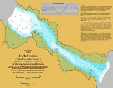
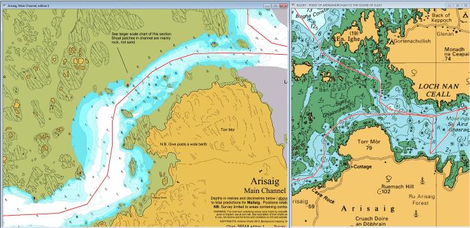
Below is an image of part of our chart of the main channel at Arisaig, at low zoom, alongside the UKHO-type chart at maximum zoom. The charts are displayed on a PC with Memory-Map plotting software. The UKHO-type chart gives you the basics but our chart shows all the detail we found when we went exploring! Our chart can be zoomed a lot further and is complemented by charts of the north channel, the inner part of the loch and an even larger scale chart of the constriction in the main channel.
|
|
‘Antares’, base for surveying in 2009, now retired to the South of France!
|

|
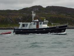
‘Otter’ - base for surveying from 2014 - do call on the VHF if you see us. |
|
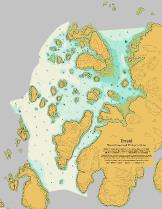
Erraid incl Tinker’s Hole |
|
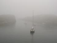
Ever been in a situation like the one above? You found your way in when the sun was shining but how will you get out? This is just one example where Antares large scale electronic charts might have made a real difference. |
|
Tinkers Hole in the mist Photo: Martin Lawrence |
|
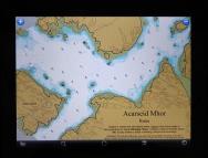
Acarseid Mhor, Rona viewed on an iPad |
|
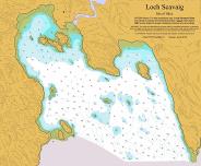
Loch Scavaig, Skye
|
|
Memory-Map. We find the free Memory-Map plotting software coupled with UKHO-type charts to be the ideal platform for our charts. It costs £25 for a one year licence for the UKHO-type UK and Ireland chart package (Marine Charts), which is excellent value. You can run our charts seamlessly with the UKHO-type charts; and with side-by-side windows you can see your position on both. And you can run them all on iPhones, iPads and Android devices as well as PCs and Macs. See example of Arisaig below: all you need is the free Memory-Map app. You can also add in OS walking maps.
|
|
ANTARES CHARTS is a source of 'unofficial' very large scale electronic charts and related pilotage information created by yachtsmen for yachtsmen. Focusing on the West Coast of Scotland it is aimed at experienced navigators, to supplement information available from more authoritative providers. The UK’s official surveying and charting authorities have not resurveyed many of the more interesting channels and anchorages of the West of Scotland since the advent of satellite positioning and often do not publish charts to a sufficiently large scale to meet the needs of the more adventurous yachtsman. Our 624 charts, covering over 600 locations, can run seamlessly with UKHO-type charts on PCs, Macs, iPads, iPhones and Android tablets and phones. There is a wide range of free apps/software available while ‘the best’ setup costs less than £50, including our charts and all UKHO-type charts for the UK and Ireland. Add in the Ordnance Survey walking maps too, if you wish! WARNING: All information described in this website has been obtained by enthusiasts without formal training. It must be used with great care and entirely at your own risk. See the risk factors outlined under ‘Making the charts’ and ‘Using the charts’. |
|
We welcome contact from users of the charts. Please let us know of any errors or inaccuracies you find. Please also let us have your thoughts on presentational issues, locations for future surveys and other material you think we could provide that you would find useful. As this is an unpaid, part time activity we do not undertake to respond to all correspondence on a timely basis but will endeavour to do so.
To send an email: Tap here
To order charts: Tap here
|
|
NOTE: This website and material obtained from it are the copyright of Antares Charts © and may not be reproduced in whole or in part without express consent; use of all such material is subject to the disclaimers and conditions posted on this website and which may be changed at any time.
|
|
The material above is subject to Memory-Map copyright. The image of part of a chart on the right is subject to © Crown Copyright and/or database rights: it is reproduced by permission of the Controller of Her Majesty’s Stationery Office and the UK Hydrographic Office (www.ukho.gov.uk). The image of part of a chart on the left is Antares Charts copyright. None of the above material is to be used for navigation |
|
Arisaig entrance channel: Antares compared with UKHO
|
|
HOME |
OUR CHARTS |
CORRECTIONS |
GUIDES & HELP |
CONTACT |